Log in
All resources
Create a design
2,996 Free Artworks of French Map
french-language maps
french-language maps of spain
bibliothèque nationale de france
guide joanne espagne et portugal-1915
1915 maps
guide joanne espagne et portugal-1906
1906 maps
french-language maps of france
maps of french algeria
maps by alexis-hubert jaillot
guide joanne espagne et portugal-1906
french-language maps of spain
guide joanne espagne et portugal-1915
1915 maps
guide joanne espagne et portugal-1906
french-language maps of spain
guide joanne espagne et portugal-1915
1915 maps
guide joanne espagne et portugal-1906
french-language maps of spain
guide joanne espagne et portugal-1915
1915 maps
guide joanne espagne et portugal-1906
french-language maps of spain
sanson maps of south america
1719 maps of south america
guide joanne espagne et portugal-1915
1915 maps
guide joanne espagne et portugal-1906
french-language maps of spain
french-language maps from ios map collection
old maps of carinthia
guide joanne espagne et portugal-1915
1915 maps
old maps of french guiana
1630s maps of brazil
guide joanne espagne et portugal-1906
french-language maps
guide joanne espagne et portugal-1915
1915 maps
guide joanne espagne et portugal-1915
1915 maps
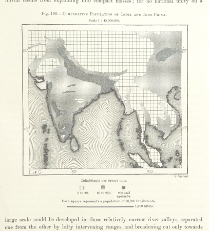
maps from the earth and its inhabitants, vol. viii
population density maps of india
eran laor cartographic collection
thomas kitchin
1645 maps of belgium
tournaisis
guide joanne espagne et portugal-1915
1915 maps
guide joanne espagne et portugal-1906
french-language maps
eran laor cartographic collection
old maps of canaan
victor levasseur - maps of france
neoclassicism,romanticism
illustrations from the sphinx of the ice fields by george roux
maps of the southern ocean
guide joanne espagne et portugal-1915
1915 maps
maps by jacques-nicolas bellin
maps by jakob van der schley
1590s maps of brazil
animals on maps
guide joanne espagne et portugal-1906
french-language maps of spain
18th-century maps of havana
1730s maps of cuba
french-language maps
1742 maps
a map of the british empire in america with the french and spanish settlements adjacent thereto
1730s maps of the caribbean
old maps of algiers
maps from gallica
guide joanne espagne et portugal-1915
1915 maps
maps of asia by jean-baptiste bourguignon d'anville
old maps of guangdong
maps of america by guillaume delisle (18th century)
1760s maps of the americas
18th-century maps of central america
1760s maps of the caribbean
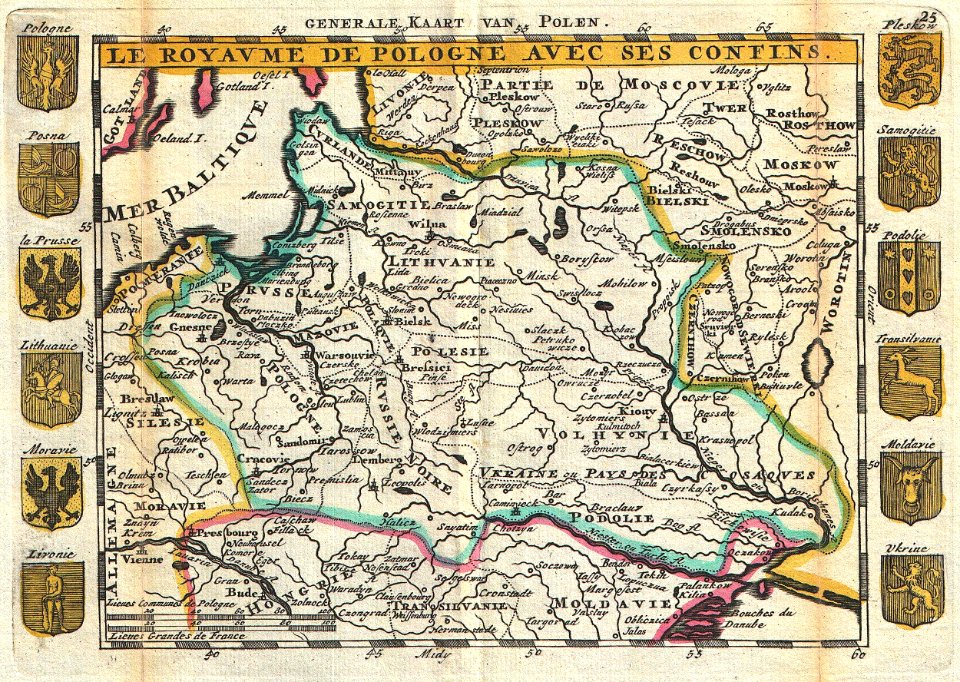
old maps of poland
1747 maps
guide joanne espagne et portugal-1915
1915 maps
1910s maps of europe
guides joanne
old maps of algiers
maps from gallica
collections of the national library of israel
louis-joseph mondhare
guide joanne espagne et portugal-1915
1915 maps
maps from gallica
maps of tlemcen
cartes de franz schrader
cayenne
maps of asia by jean-baptiste bourguignon d'anville
french-language maps
victor levasseur - maps of france
1847 maps
algeria in the 1880s
old maps of algeria
nouvelle géographie universelle, vol. ix
eran laor cartographic collection
19th-century maps of the sea of marmara
19th-century maps of the bosphorus
maps from the earth and its inhabitants, vol. xi
africa in the 1890s
maps of the duchy of mantua
guillaume sanson
maps by alain manesson-mallet
1719 maps of africa
french-language maps of asia
1750s maps of asia
18th-century maps of the strait of magellan
1700s maps of argentina
guide joanne espagne et portugal-1915
1915 maps
algeria in the 1880s
old maps of algeria
19th-century satirical maps
1882 maps of europe
nouvelle géographie universelle, vol. ix
eran laor cartographic collection
geneviève brossard de beaulieu
jean-françois de la pérouse
eran laor cartographic collection
carolus allard
the french invasion of ireland in '98 (1890) by gribayèdoff
maps from the mechanical curator collection
algiers in the 19th century
old maps of algiers
maps of eastern europe
french-language maps
french-language maps of europe
1890s maps of vienna
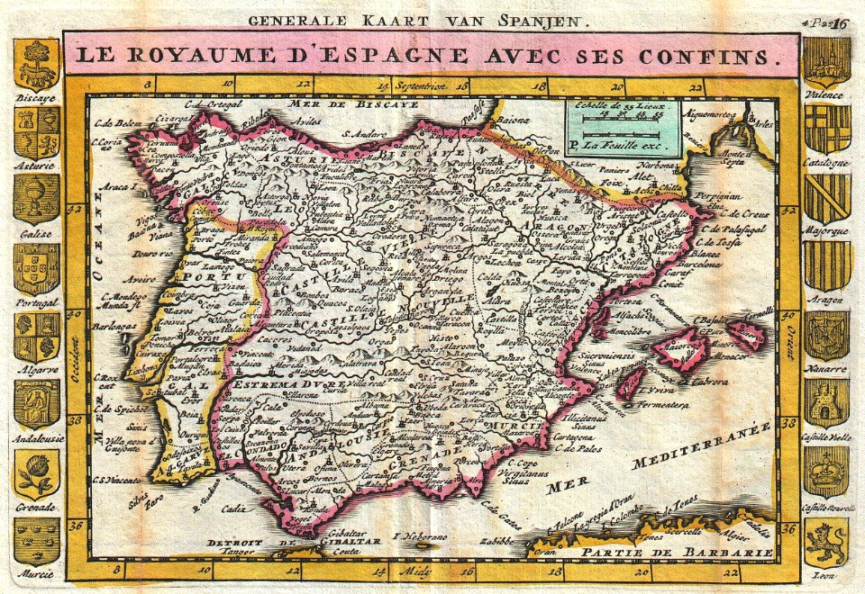
1810s maps of the iberian peninsula
maps of spain by tomas lopez
18th-century maps of catalonia
daniel de la feuille
map of the circle of the rhineland by sanson
maps by nicolas sanson
maps by pieter mortier
indochina
eran laor cartographic collection
latin-language maps
19th-century maps of maastricht
maps in hcl (maastricht)
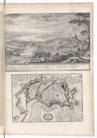
old maps of geneva
baroque
maps from the earth and its inhabitants, vol. xi
algeria in the 1800s
18th-century maps of veneto
1700s maps of slovenia
book illustrations by robida
1879 illustrations
guide joanne normandie-1912
1912 maps of france
maps by alexis-hubert jaillot
1730s maps of france
maps from géographie illustrée de la france et de ses colonies
1868 maps
19th-century maps of vaucluse
1852 maps of france
maps from the earth and its inhabitants, vol. xii
africa in the 1890s
william henry toms
henry popple
maps from the earth and its inhabitants, vol. xii
africa in the 1890s
guide joanne normandie-1912
1912 maps of france
guide joanne normandie-1912
1912 maps of france
18th-century french nautical charts
historical images of souda bay
1740s maps of the iberian peninsula
daniel de la feuille
map of the upper rhenian circle by sanson
maps by nicolas sanson
guide joanne normandie-1912
1912 maps of france
17th-century maps of south america
maps by nicolas sanson
1667 sanson map of africa
maps by nicolas sanson
maps by pieter mortier
1700 maps of africa
maps of the iberian peninsula by guillaume delisle
1780s maps of the iberian peninsula
maps of the land of valkenburg
guillaume sanson
french renaissance
kartli
tourism advertising posters of germany
french-language maps of germany
eran laor cartographic collection
french-language maps
moïse-jean-baptiste fouard
corsair wars
david rumsey historical map collection
andrew dury
maps by alexis-hubert jaillot
robert cordier (engraver)
maps by alexis-hubert jaillot
maps by guillaume sanson
1570s maps of russia
frans hogenberg
201 - 300 of 2,996
Next page
/ 30